Miscellaneous Hydrology Tools for ArcGIS - Trace Downstream Tool
Here is part three of the blog post on the Miscellaneous Hydrology Tools for ArcGIS. This post covers a tool called the Trace Downstream tool. You can read the original blog post by clicking HERE or download the tool be clicking HERE. Although there are tools in ArcGIS for tracing flows along vector networks there is no out-of-the-box tool for tracing downstream grid cells. That is where this tool comes in. Note that this tool uses a D8 flow algorithm. If there are diversions, like there might be in a vector-based hydrological network, then those won't show up. The assumption is that water flows downhill and that it is controlled entirely by topography.
In the picture on the left we have the output from the Find Inflow Cells Tool described in my November 12th post HERE. You can use any point(s) that you are interested in tracing downstream flow from. This is just an example that fits into a recent workflow that I used and illustrates how the two tools might work in tandem. The small blue dots represent points that I want to trace downstream. These are inflow cells when this little part of the watershed was cut off from the remaining watershed (e.g. digitized line on the map).
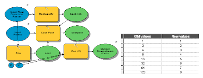
The picture below shows the guts of the model as you would view it from ArcGIS Model Builder. The Trace Flow Downstream is a fairly simple tool. Using the flow direction from the previous tool and the points this simple tool takes a flow direction raster and reclassifies it into a backlink raster and then traces the path using the cost path tool. The reclassification is shown above with flow direction values in the left column and backlink values in the right column.
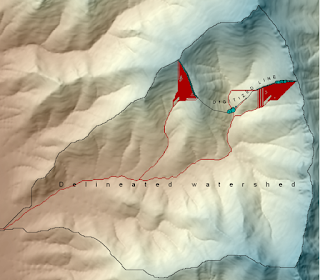 The picture on the right shows the results of the Trace Downstream tool. Input points are the light blue points and red cells represent grid cells located downstream from those points. This tool could be used for a number of hydrological applications. For example, we may be interested in tracing a pollutant downstream. We may also be interested in identifying concentrated flow paths from overland flow. Finally we might want to use a tool such as this one to identify locations for placing erosion or pollutant control measures in order to maximize efficacy while controlling costs. For example, it might be most effective to place two to three measures in areas where flow is concentrated rather than dozens along the perimeter of the inflow area.

 The picture on the right shows the results of the Trace Downstream tool. Input points are the light blue points and red cells represent grid cells located downstream from those points. This tool could be used for a number of hydrological applications. For example, we may be interested in tracing a pollutant downstream. We may also be interested in identifying concentrated flow paths from overland flow. Finally we might want to use a tool such as this one to identify locations for placing erosion or pollutant control measures in order to maximize efficacy while controlling costs. For example, it might be most effective to place two to three measures in areas where flow is concentrated rather than dozens along the perimeter of the inflow area.
No comments:
Post a Comment