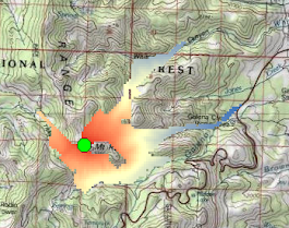
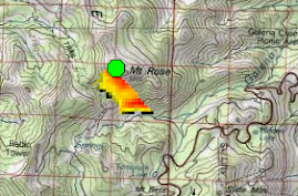
Similar to the concept of a watershed being the contiguous area draining into a central point or a viewshed being the area that is visible from a given point a skished is an area that accessible immediately downhill from a given point without requiring uphill travel. The skished also provides an objective definition of vertical drop/gain, which is an important criterion for evaluating the amount of effort required to ascend a peak. Vertical drop/gain can complement other commonly-used metrics for mountains, such as summit elevation and topographic prominence. Skished can also be used to help map danger due to avalanches and rockslides although the skished concept doesn’t explicitly account for energy that can be built up as the avalanche/rock slide moves down the slope. Avalanches have been known to go upslope if the momentum is great enough. Therefore, this tool should NOT be used as the final determination as to which slopes are safe and which aren’t.
A ski shed uses 3x3 neighborhood analysis to seek cells that are at an elevation below the focal cell and have a slope that is greater than the threshold slope. The process repeats until there are no more cell or until the MaxDistance is reached. It is a very simple type of cellular automata model.
Ski shed for Mount Rose summit using a 5 degree and a 15 degree minimum slope threshold. Elevation changes are 4563 feet going down Galena Creek, 3805 feet going down Whites Creek, and 1817 going down Bronco Creek. The elevation difference for the south face of Mt. Rose using the 15 degree threshold is 2444 feet.

You can download the ski shed tool by clicking HERE.


No comments:
Post a Comment